Weather
Last update: 25.07.2026, 11:00
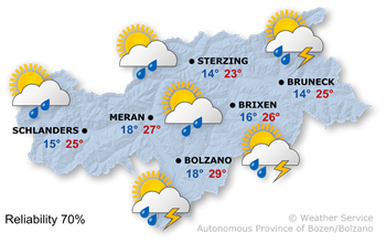
Weather today
Moist air masses will temporarily move into the Alpine region from the south-west.
A mix of sunshine and clouds. It will remain mostly dry in the morning, but thundery showers are likely to develop during the afternoon and into the evening.
The maximum temperatures will range from 23° to 29°.
Further development

33°/10°
Monday, 27.07

35°/10°
Tuesday, 28.07
35°/12°
Wednesday, 29.07

37°/13°
Thursday, 30.07
Monday will be quite sunny thanks to the northerly wind, with only a slight chance of a brief shower in a few places.
Tuesday will be very sunny, with clear skies for much of the day.
Wednesday will also start off with widespread sunshine, but the risk of thunderstorms will increase slightly during the second half of the day.
Thursday will be sunny across the entire region, and temperatures will become hot.
Mountain weather today
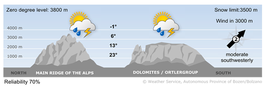
Sun, clouds, and thundery rain showers
Conditions in the mountains will be unsettled, although the first half of the day will remain mostly dry. During the afternoon, showers and thunderstorms will become widespread.
upper wind
2 - moderate wind
16-30 km/h
3 - strong wind
31-60 km/h
4 - stormy wind
> 60 km/h